Indonesia watches Anak Krakatau as officials warn tsunami risk matters more than volcanic eruptions
Authorities in Indonesia's Banten Province are monitoring Mount Anak Krakatau after multiple eruptions and a magnitude 5.3 earthquake, with officials emphasising tsunami preparedness while experts say there is no evidence the two events are directly linked.
- Banten authorities say tsunami risk remains the primary concern following Anak Krakatau's eruptions.
- Scientists say there is no evidence the magnitude 5.3 earthquake triggered the volcanic activity.
- Mount Anak Krakatau remains at Level III (Alert) with a three-kilometre exclusion zone.

Authorities in Indonesia's Banten Province are closely monitoring volcanic activity at Mount Anak Krakatau in the Sunda Strait, with officials stressing that the primary concern is not the eruption itself but the potential for a tsunami.
The warning comes after a magnitude 5.3 tectonic earthquake struck the Sunda Strait region early on 8 July, followed by a series of eruptions from Mount Anak Krakatau, one of Indonesia's most active volcanoes.
Banten Regional Disaster Management Agency (BPBD) chief Lutfi Mujahidin said provincial authorities were focused on assessing whether volcanic activity could trigger a tsunami that would threaten coastal communities.
"Our focus is not the volcanic eruption itself, but a tsunami. If it erupts, only ash will reach us," Lutfi said on Thursday.
According to Lutfi, any decision to recommend evacuations would depend on whether volcanic activity creates conditions capable of generating a tsunami.
"It depends. If it is merely an eruption above the surface, does it trigger an earthquake or not? If it does not cause a tsunami, then there is no problem," he said.
Officials estimate that coastal communities could have approximately 40 minutes to evacuate if an eruption were assessed as having tsunami potential.
"From the moment of the eruption, there is a 40-minute window. So, when an eruption occurs and there is tsunami potential, people have 40 minutes. If the public do not understand the situation, they may remain relaxed. Therefore, if the sea suddenly recedes, do not simply stay where you are," Lutfi said.
BPBD Banten said it continues to monitor information issued by Indonesia's Centre for Volcanology and Geological Hazard Mitigation (PVMBG). Emergency response and evacuation training has also been provided to members of the Water Rescue and Lifeguard Agency (Balawista) to improve readiness along the coast.
"In terms of information, we follow PVMBG. We have also provided education on self-evacuation procedures. Balawista personnel have likewise received rescue training," Lutfi said.
He urged residents and visitors not to panic but to familiarise themselves with evacuation routes and designated assembly points in areas vulnerable to natural disasters.
Banten authorities focus on tsunami risk
The heightened monitoring follows a magnitude 5.3 earthquake that struck the Sunda Strait at 02:44 local time (WIB) on Wednesday.
Indonesia's Meteorology, Climatology and Geophysics Agency (BMKG) said the shallow tectonic earthquake was caused by subduction activity and occurred beneath the sea approximately 62 kilometres south-west of Sumur in Pandeglang Regency, Banten Province.
The earthquake was recorded at a depth of 43 kilometres.
BMKG stated that modelling showed the earthquake had no potential to generate a tsunami.
"The earthquake was a shallow-focus event caused by subduction activity," BMKG Director of Earthquakes and Tsunamis Wijayanto said in a statement issued after the event.
The tremor was felt strongly in parts of Pandeglang Regency, particularly in Sumur District, where residents rushed outdoors after being awakened by the shaking.
"The tremor was quite significant," said Kipong, a resident of Cigorondong Village in Sumur District.
"My family and I ran out of the house to save ourselves," he added.
Another resident, Siti Morensza, said the shaking was strong enough to rattle windows inside her home.
"Even my bedroom windows rattled," she said.
Pandeglang BPBD chief Riza Ahmad Kurniawan said no official reports of damage had been received following the earthquake.
"So far, there have been no reports of damage submitted to the BPBD Operations Control Centre. However, our teams continue to monitor and coordinate regarding the situation and conditions," he said.
Authorities advised residents to remain calm, continue their daily activities and rely only on official information issued through BMKG's communication channels.
Earthquake located in Sunda Strait megathrust zone
BMKG said the earthquake occurred within the Sunda Strait Megathrust, an active section of the broader Sunda subduction system.
The Sunda subduction zone stretches along the boundary between the Eurasian Plate and the Indo-Australian Plate, where the latter continues to move beneath the former at an estimated rate of 60 to 70 millimetres per year.
Subduction zones, often referred to as megathrust zones, are capable of generating large earthquakes.
According to BMKG, the strongest shaking from Wednesday's earthquake reached intensity level IV on the Modified Mercalli Intensity (MMI) scale in Sumur.
Scientists from BMKG and Indonesia's National Research and Innovation Agency (BRIN) have identified the Sunda Strait Megathrust as a seismic gap, meaning the area has experienced a prolonged period without a major earthquake despite continued tectonic strain accumulation.
Various scientific assessments have estimated that the zone could potentially generate a large earthquake with a magnitude of between 8.7 and 9.0 or greater. Experts have warned that such an event could generate a major tsunami affecting parts of the southern coasts of Java and Sumatra.
Anak Krakatau records multiple eruptions
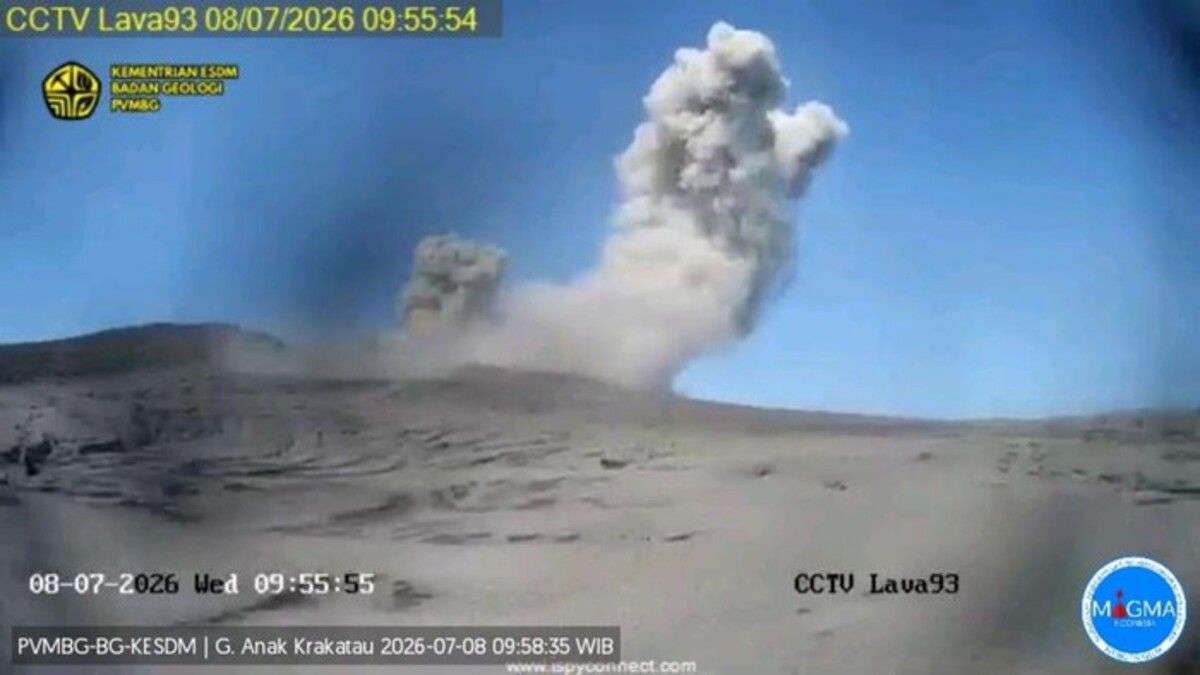
Several hours after the earthquake, PVMBG reported a series of eruptions at Mount Anak Krakatau, which is located in the Sunda Strait between the islands of Java and Sumatra.
By 09:54 WIB on 8 July, the volcano had erupted six times in less than ten hours.
The first eruption occurred at 00:11 WIB. The event could not be observed visually due to monitoring conditions but was recorded by seismographs with a maximum amplitude of 24 millimetres and a duration of 40 seconds.
At 05:50 WIB, the volcano produced an ash column reaching approximately 250 metres above the summit, or around 407 metres above sea level. Observers reported thick grey, brown and black ash drifting towards the north and north-west.
The eruption lasted 44 seconds and recorded a maximum amplitude of 26.1 millimetres.
A further eruption occurred at 07:11 WIB, producing another ash column about 250 metres above the summit. The plume, ranging in colour from grey to black, drifted towards the north-west.
That eruption lasted 31 seconds and reached a maximum amplitude of 44.4 millimetres.
At 08:42 WIB, another eruption generated a black ash column approximately 100 metres above the summit, or 257 metres above sea level. The eruption lasted 40 seconds and recorded a maximum amplitude of 35 millimetres.
The volcano erupted again at 09:35 WIB, sending an ash column around 200 metres above the summit, or 357 metres above sea level. The eruption lasted approximately 27 seconds and produced a maximum amplitude of 49 millimetres.
Another eruption followed at 09:54 WIB.
"This eruption was recorded on a seismograph with a maximum amplitude of 45 millimetres and a duration of 13 seconds," said Deny Mardiono, an officer at the Anak Krakatau Volcano Observation Post, in a report submitted to PVMBG.
No evidence earthquake triggered volcanic activity
Despite the occurrence of both events on the same day, PVMBG said there was currently no evidence linking the earthquake to the increased volcanic activity.
Heruningtyas Desi Purnamasari, head of the Geological Agency's Volcano Working Team, said monitoring data showed no indication that eruptive activity had increased following the earthquake.
"At present, there is no indication of increased eruptive activity following this morning's earthquake," she said.
According to Heruningtyas, signs of elevated activity at Anak Krakatau had already been detected in early June through measurements of sulphur dioxide emissions and observations of shallow thermal anomalies.
"This means the escalation process was already underway before the eruption on 2 July 2026 and is more strongly linked to magma dynamics or shallow gas activity within the Anak Krakatau system itself," she told Tempo.
Despite the repeated eruptions throughout the day, PVMBG has maintained Mount Anak Krakatau at Level III (Alert) status. The agency continues to advise residents, tourists and climbers not to approach the volcano or conduct activities within a three-kilometre radius of the active crater.
Authorities have also urged the public to monitor official updates and follow guidance issued by disaster management and volcanology agencies as activity at the volcano continues to be closely observed.