Kalimantan fires deepen haze crisis as air quality worsens
Thick haze from forest and land fires is worsening air quality across Kalimantan, Indonesia, with Banjarbaru recording hazardous PM2.5 levels and fires disrupting schools, flights and public activity. Authorities are expanding firefighting operations as the dry season intensifies.
- Banjarbaru recorded PM2.5 of 389.4 micrograms per cubic metre on 19 August.
- Fires have disrupted schools, flights and outdoor activity across several Kalimantan cities.
- Authorities are deploying personnel, helicopters and weather modification as fires spread across peatland areas.

Forest and land fires have spread across several parts of Kalimantan during August, blanketing cities in thick haze, worsening air quality and disrupting public activities as authorities step up firefighting operations during the dry season.
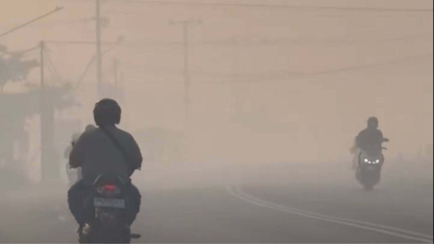
The most severe conditions have been reported in Banjarbaru, South Kalimantan, where the concentration of fine particulate matter known as PM2.5 reached 389.4 micrograms per cubic metre on Wednesday, 19 August, according to Indonesia's Meteorology, Climatology and Geophysical Agency (BMKG). The level was well above the 250.5 micrograms per cubic metre threshold for the hazardous or very unhealthy category.
PM2.5 refers to airborne particles measuring 2.5 micrometres or smaller. Higher concentrations pose greater risks to public health.
The thick smoke has reduced visibility in some locations to about three metres, while fires were still visible at several roadside locations on Wednesday afternoon.
The worsening haze has begun to disrupt public services. Banjarbaru's Education Office ordered affected schools to delay their starting time to 9 a.m. from Thursday, 20 August, while schools in areas with severe haze were told to make adjustments according to local conditions.
"Schools can begin learning activities at 9 a.m. for schools affected by the haze," Banjarbaru Education Office head Abdul Basid was quoted as saying by detikKalimantan on Thursday.
The haze also caused delays to 12 flights at Syamsudin Noor International Airport.
Authorities strengthen response in South Kalimantan
Deputy Coordinating Minister for Food Affairs Hanif Faisol Nurofiq called for South Kalimantan to deploy greater resources to control the fires.
He made the call during a strategic coordination meeting on forest and land-fire management with the provincial Forestry Office, the Regional Disaster Management Agency (BPBD) and other members of the fire task force in Pangayuan, Banjarbaru, on Tuesday, 18 August.
According to the South Kalimantan provincial Media Centre, the provincial Public Works and Spatial Planning Office has deployed 53 personnel to fire command posts since 10 August and has operated a number of pumps to maintain protected forest areas by preventing dry conditions that could increase the risk of fires.
Fires worsen across Central and West Kalimantan
Haze blanketed Palangka Raya, Central Kalimantan, from Tuesday morning, 18 August, with smoke visible along several roads, particularly around Jalan Tingang and Jekan Raya district. Reduced visibility has raised health concerns for people working or travelling outdoors.
The Palangka Raya BPBD recorded 298 forest and land-fire incidents covering 261.41 hectares between 1 June and 19 August, according to Antara Kalteng.
A separate report said BPBD Palangka Raya had recorded 274 incidents affecting more than 251 hectares. Air quality deteriorated to an AQI of 154, while the Central Kalimantan Provincial Health Office recorded 2,052 acute respiratory infection (ARI) cases between 7 August and 14 August. A separate report put ARI cases in Palangka Raya at 12,394.
In Kotawaringin Barat, the local government declared a forest and land-fire disaster emergency from 21 August to 4 September as hotspots increased. BPBD data on 18 August showed 859.49 hectares of burned land, 189 fire incidents and 461 hotspots.
"The incidence of forest and land fires and hotspots in our area has increased again. Currently, the area of land burned by forest and land fires has reached 859.49 hectares. There have been 189 incidents and 461 hotspots," Regent Nurhidayah said on 19 August.
Kumai and Arut Selatan recorded the largest affected areas. Kumai had 584.41 hectares burned, 63 incidents and 124 hotspots, while Arut Selatan recorded 180.475 hectares, 98 incidents and 226 hotspots.
"We are moving to the locations and dividing schedules with the other teams. Our focus at the moment is on fire points that are already approaching residential areas," Nurhidayah said.
In West Kalimantan, Pontianak recorded Indonesia's worst air quality on Thursday morning, 20 August, according to IQAir. At 6:56 a.m. local time, its air-quality index was 191, classified as unhealthy, while PM2.5 reached 112 micrograms per cubic metre, or 22.4 times the World Health Organisation's air-quality guideline.
The deterioration has been linked to forest and land fires producing thick haze across Pontianak and surrounding areas. Mayor Edi Rusdi Kamtono has declared a forest and land-fire emergency.
"We are doing this to strengthen coordination in handling the fires, both in preventing fires and dealing with their impact on public health," Edi said on 10 August.
West Kalimantan recorded 4,041 fire hotspots, including 3,560 medium-level and 352 high-level hotspots. Pontianak also recorded fire points around Jalan Sepakat II Ujung and several smaller locations in North Pontianak. The haze has reportedly also been influenced by fires in surrounding regencies, including Ketapang, Kubu Raya, Kayong Utara and Landak.
Health impacts grow as air quality worsens
Air pollution from the fires has affected several cities across Kalimantan.
IQAir data showed that air quality in Pontianak had been in the unhealthy category since 31 July, while Palangkaraya's air quality had at one point reached the hazardous category.
The West Kalimantan Health Office reported a 5 per cent increase in acute respiratory infection cases.
The Central Kalimantan Provincial Health Office recorded 2,052 ARI cases between 7 August and 14 August.
Greenpeace Indonesia Forest Campaigner Belgis Habiba said the fires were affecting both the environment and public health.
"When forests burn, people living in surrounding areas are forced to breathe polluted air and face health risks from exposure to forest and land-fire smoke," Belgis said.
"The state must take serious action to break the cycle of forest and land fires, rather than treating them simply as an annual 'event'," she said.
Forestry minister inspects Central Kalimantan firefighting
Forestry Minister Raja Juli Antoni visited firefighting efforts at Camp Peat Tumbang Nusa in Pulang Pisau Regency, Central Kalimantan, on Wednesday, while also inspecting efforts in Petuk Katimpun, Palangka Raya.
The government has strengthened firefighting efforts through weather modification operations and additional water-bombing helicopters deployed by BNPB.
Raja Juli stressed the need for stronger cooperation between agencies as Central Kalimantan entered the peak of the dry season and fires continued to affect peatland.
During the visit, the minister planted an ironwood tree in a nursery before inspecting an automatic peatland water-level monitoring device.
The device showed a water level of around minus 0.99 metres. The Forestry Ministry said the reading indicated hazardous conditions because the ideal peatland water level should be above minus 0.4 metres.
Raja Juli then met representatives of the Pulang Pisau Regency Government, BNPB, BMKG, the Indonesian Military (TNI), National Police (Polri), local governments, Manggala Agni, the Fire-Aware Community (MPA) and other groups involved in firefighting operations.
"What I respect, am proud of and care about most are the colleagues who are struggling in the field, whether from the TNI, Polri, BNPB, BPBD or Manggala Agni," Raja Juli said.