Kalimantan fires intensify as haze raises cross-border concerns
Forest and land fires are intensifying across West and Central Kalimantan, with haze affecting communities, tourism and air travel while authorities monitor smoke movement towards Malaysia.
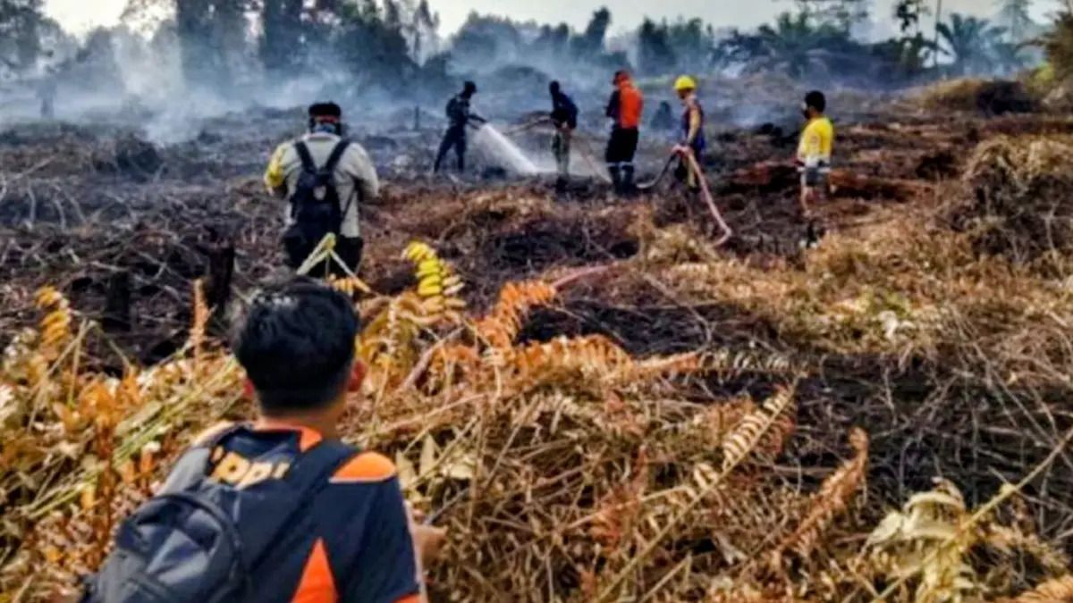
- West and Central Kalimantan are experiencing extensive forest and land fire activity during August.
- Authorities are monitoring smoke movement towards Malaysia as haze affects communities and tourism.
- Indonesia has prioritised three Kalimantan provinces for fire management alongside three provinces in Sumatra.

Forest and land fires continue to affect several parts of Kalimantan, with West Kalimantan and Central Kalimantan among the areas experiencing significant fire activity in August.
In West Kalimantan, authorities have increased monitoring of smoke that could cross the border into Malaysia, while fires have also affected areas within Pontianak. In Central Kalimantan, fires have disrupted tourism and contributed to increasingly dense haze.
The situation has also raised concerns over transboundary haze, particularly in Sarawak, where Indonesian authorities are monitoring the movement of smoke from fire-affected areas.
West Kalimantan strengthens monitoring of transboundary smoke
Manggala Agni Kalimantan XI/Singkawang has increased monitoring of smoke from forest and land fires that could move towards Malaysia.
The fire-control agency is monitoring the direction, thickness and extent of smoke, including its potential movement towards border areas. The monitoring is being conducted as part of an early-warning system for transboundary smoke.
Yuyu Wahyudin, head of the Manggala Agni Kalimantan XI/Singkawang operations unit, said officials were systematically observing, detecting, measuring and reporting the spread and density of smoke crossing national borders, including smoke potentially moving towards Malaysia.
Monitoring involves observation posts, watchtowers and routine patrols, particularly in areas where smoke could spread towards the border. Officials are also using satellite imagery, remote-monitoring cameras and air-quality equipment to measure PM2.5, PM10 and Indonesia's Air Pollution Standard Index (ISPU).
Wind direction and speed, smoke density and range, air-quality readings, fire hotspots and reports of health complaints are among the factors being monitored.
The information is also being exchanged with neighbouring countries, particularly Malaysia, as part of coordination on potential transboundary smoke.
Smoke from West Kalimantan moves towards Sarawak
Local reporting has identified West Kalimantan as a source of smoke moving towards Sarawak.
Pontianak Post reported that the Indonesian authorities were strengthening efforts to prevent smoke from crossing the border into Sarawak, including by optimising weather-modification operations when cloud growth provided suitable conditions.
A separate report by Jurnal Borneo said smoke from West Kalimantan towards Kuching, Sarawak, had been detected between 7 and 11 August, citing monitoring by the ASEAN Specialised Meteorological Centre (ASMC).
The report said dozens of activists from the Smoke Emergency Alliance held a protest in Pontianak on 14 August over recurring forest and land fires and worsening haze in West Kalimantan. Activists distributed masks to road users during the action.
Fires also reported in Pontianak
Forest and land fires have occurred within Pontianak itself.
Pontianak Post reported that a fire in Sepakat II, Pontianak Tenggara, burned approximately two hectares of land. The report noted that several locations in the area had previously experienced fires.
The fires have occurred amid broader fire activity across West Kalimantan.
According to data presented by the West Kalimantan branch of environmental organisation WALHI, cited by Jurnal Borneo, 18,618 hotspots were recorded across the province between January and July 2026. The organisation estimated that fires had affected approximately 28,680 hectares across 14 regencies and cities during that period.
Some of the detected hotspots were assessed as having medium to high confidence, according to the organisation's analysis.
Haze affects communities in West Kalimantan
The worsening haze has also affected communities elsewhere in West Kalimantan.
Pontianak Post reported that 10,081 residents in Kapuas Hulu had suffered acute respiratory infections (ARI), with prolonged dry conditions and haze among the factors associated with the situation.
Local authorities and fire-control teams continue to monitor fire locations and air quality as the dry conditions persist.
Central Kalimantan records extensive fire activity
Central Kalimantan is also experiencing extensive forest and land fires, particularly in Kotawaringin Timur Regency.
Local data reported by Berita Sampit showed that 2,466 hotspots had been recorded in Kotawaringin Timur by mid-August. The same report said 317 fire incidents had affected approximately 1,207.3 hectares of land.
The figures underline the scale of fire activity in the regency during August.
Earlier reporting by ANTARA Kalteng said hundreds of hotspots had been detected in Kotawaringin Timur and that the local fire-response task force was prioritising field verification of hotspots before deploying firefighting resources.
Haze disrupts tourism in Central Kalimantan
In neighbouring Kotawaringin Barat, increasingly dense haze has begun affecting tourism and air travel to Tanjung Puting National Park.
DetikKalimantan reported that foreign tourists travelling to the park had experienced flight delays because of worsening smoke. Muhammad Alwan, head of tourism destination development in Kotawaringin Barat, said the delays had affected international visitors travelling according to scheduled itineraries.
Tanjung Puting is a major tourist destination in Central Kalimantan and attracts visitors from countries including the United States, European countries, India, Japan and China.
The local government said that, as of 11 August, the reported impact was limited to flight delays, with no reports of foreign tourists cancelling their visits because of the haze. Authorities were continuing to monitor the situation because the main foreign-tourist season generally runs from June to early October.
Malaysia monitors the cross-border impact
The movement of smoke towards Sarawak has prompted increased monitoring on the Malaysian border.
Indonesian fire-control officials said their monitoring system was designed to identify potential transboundary smoke at an early stage and provide information to both Indonesian authorities and neighbouring countries.
The system combines ground observations with satellite imagery, remote cameras and air-quality measurements. Officials also monitor wind conditions and hotspot locations to determine the likely direction and range of smoke movement.
Pontianak Post previously reported that schools in Serian, Sarawak, were temporarily closed because air pollution remained in the unhealthy category.
The local report said the school closures were extended until 14 August as unhealthy air quality continued.
Regional haze concerns increase
Pontianak Post has also reported concerns over smoke from Kalimantan affecting Malaysia and Singapore, prompting greater attention to transboundary haze.
The latest monitoring by Manggala Agni focuses particularly on the possibility of smoke reaching Malaysia. Officials said the information collected would support early warnings, data exchange and coordination with authorities in neighbouring countries.
In West Kalimantan, the proximity of fire-affected areas to the Malaysian border has made monitoring wind direction and smoke movement a priority.
Government response continues
The Indonesian government has designated West Kalimantan, Central Kalimantan and South Kalimantan among six priority provinces for forest and land fire management, alongside Riau, Jambi and South Sumatra.
In West Kalimantan, authorities have strengthened hotspot monitoring, patrols, field inspections and firefighting operations. Weather-modification operations have also been used when atmospheric conditions allow.
The Ministry of Forestry has sought to increase the availability of rainfall in fire-prone areas through weather modification, while firefighting teams continue ground operations.
The Indonesian Meteorology, Climatology and Geophysics Agency (BMKG) also maintains monitoring of fire-weather conditions across Indonesia and the wider ASEAN region.
Fire activity remains widespread
National data from the Ministry of Forestry showed that Indonesia recorded 107,465.47 hectares of forest and land affected by fires between January and June 2026.
The figure was 120 per cent higher than the corresponding period in 2019, 110 per cent higher than in 2023 and 366 per cent higher than in 2025.
West Kalimantan remains one of the provinces with the largest areas affected by fires, while Central Kalimantan continues to report large numbers of hotspots and extensive burned areas.
With fires continuing in both provinces, Indonesian authorities are maintaining fire suppression and monitoring operations while paying particular attention to smoke movement towards the Malaysian border.