Tropical Storm Noul strengthens as southern China braces for weekend landfall
Tropical Storm Noul strengthened on 24 July as it moved towards the Luzon Strait, prompting weather warnings across the northern Philippines, Taiwan and Cambodia while forecasters projected landfall in Guangdong over the weekend.
- Tropical Storm Noul is forecast to strengthen before making landfall in Guangdong over the weekend.
- Weather warnings have been issued across the northern Philippines, Taiwan, Hong Kong and Cambodia.
- Southern China's Guangdong coast is expected to face the storm's most severe impacts.

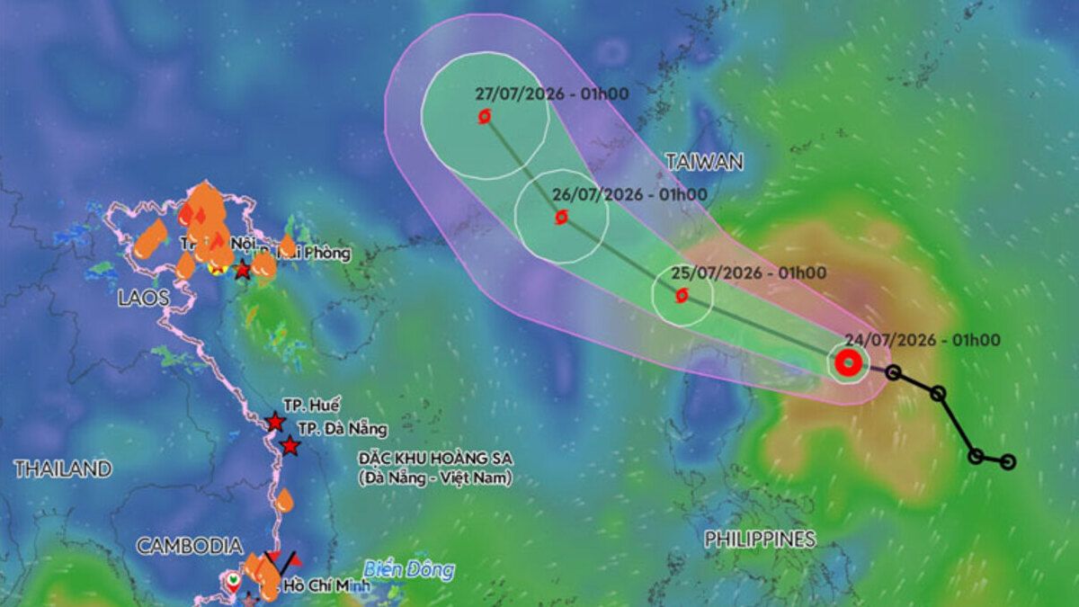
Tropical Storm Noul continued to strengthen on Friday as it moved west-north-west towards the Luzon Strait, prompting weather warnings across the northern Philippines, Taiwan and parts of Southeast Asia, while forecasters projected landfall in China's Guangdong Province over the weekend.
According to the Japan Meteorological Agency (JMA), Noul was located at 18.0°N, 123.5°E, about 150 kilometres east of northern Luzon as of 00:45 UTC on 24 July. The storm was moving west at 30 km/h, with a central pressure of 996 hectopascals (hPa), maximum sustained winds of 74 km/h and gusts reaching 111 km/h.
The JMA classified Noul as a tropical storm and forecast it to strengthen into a Severe Tropical Storm within 12 hours, with sustained winds increasing to 93 km/h and central pressure falling to 990 hPa.
Forecast to approach Guangdong at peak strength
Forecasters expect Noul to pass through the Luzon Strait on Friday before tracking across the northern South China Sea.
The JMA projected the storm would gradually curve north-westwards, approaching China's Guangdong coast on 25–26 July and reaching peak intensity shortly before or at landfall.
At its strongest, Noul is forecast to produce sustained winds of 111 km/h with a minimum central pressure of 980 hPa before weakening rapidly after moving inland.
The projected track places the centre of the storm near or just inland of the Guangdong coastline northeast of Hong Kong, before it moves north-north-west into inland southern China.
The Hong Kong Observatory said Noul was expected to enter the northeastern South China Sea on Friday and Saturday while continuing to intensify as it approached eastern Guangdong. However, it noted that uncertainty remained over the exact landfall location and how close the storm would pass to Hong Kong.
The observatory warned that Guangdong's coastal areas could experience strong winds, heavy rain, thunderstorms, rough seas and large waves from Saturday into Sunday.
Taiwan issues sea warning
Taiwan's Central Weather Administration (CWA) issued a sea warning for Noul late on Thursday after the storm intensified east of the Philippines.
As of 5 a.m. Friday, the CWA said the storm was centred about 530 kilometres southeast of Oluanpi, Taiwan's southernmost point, moving west-north-west at 25–28 km/h, with maximum sustained winds of 65 km/h.
Forecasters said Noul was expected to retain tropical storm strength while passing through the Bashi Channel south of Taiwan before strengthening further over the South China Sea, potentially reaching typhoon intensity before making landfall in Guangdong.
The storm's outer rainbands were expected to begin affecting Taiwan on Friday, with rainfall increasing in eastern Taiwan and the Hengchun Peninsula later in the day.
The closest approach to Taiwan is forecast for Saturday, when Hualien, Taitung and the Hengchun Peninsula could receive heavy to extremely heavy rainfall. Southern Taiwan may also experience localised heavy rain, while scattered showers are forecast for Taipei, New Taipei City, Keelung, Yilan and mountainous areas.
The CWA also warned of long-period swells from Friday night through early Sunday along Taiwan's eastern and south-western coasts, the Hengchun Peninsula, Penghu County, Orchid Island and Green Island.
Although the storm is expected to move away from Taiwan by Sunday and Monday, moist southerly winds are likely to continue producing localised heavy rain in Taitung and the Hengchun Peninsula before conditions gradually improve next week.
Northern Philippines faces deteriorating conditions
The JMA said deteriorating weather conditions were expected across the Luzon Strait, northern Philippines and Taiwan's southern tip over the next 12 to 24 hours.
Noul's tropical-storm-force winds extend up to 330 kilometres from the storm's centre, increasing the risk of strong winds, heavy rainfall and rough seas across affected coastal waters.
Cambodia warns of widespread rain
Although Cambodia is not forecast to lie directly in the storm's path, the Ministry of Water Resources and Meteorology said Noul would strengthen the south-west monsoon over the region through Wednesday.
The ministry forecast widespread rain, thunderstorms and gusty winds across much of the country.
Lowland provinces, including Phnom Penh, Siem Reap, Battambang, Kampong Cham, Kandal and several neighbouring provinces, could see rain affecting around 50 per cent of their areas.
Highland provinces, including Mondulkiri, Ratanakiri, Preah Vihear, Stung Treng and the Cardamom and Dangrek mountain ranges, are forecast to experience thunderstorms and gusty winds affecting about 70 per cent of their areas.
Similar conditions are expected along Cambodia's coastal provinces of Koh Kong, Sihanoukville, Kampot and Kep, where sea waves are forecast to reach up to 1.75 metres.
Authorities urged residents, particularly those travelling by road or water, to remain alert for heavy rain, thunderstorms and strong winds.
Greatest threat expected for southern China
Current forecasts indicate that the greatest impact from Noul is likely to occur along the coast of Guangdong, including areas near Hong Kong and Macau, where the storm is expected to arrive near its peak intensity.
Meteorological agencies warned that the region could experience destructive winds, torrential rainfall, storm surge, rough seas and large waves as the storm approaches over the weekend.